Super typhoon level, how strong is it?
Original Fengyun Mengyuan Guoke
Recently, the typhoon Xuanlannuo, which came from the depths of the sea, trudged to the offshore area of China, and its strong intensity and changeable path attracted a lot of attention.
The Central Meteorological Observatory issued a typhoon blue warning for Xuanlannuo, and many places also launched emergency response against Taiwan.
As the first super typhoon this year, "Xuanlannuo" was so powerful that it even swallowed another "typhoon embryo" on the way.
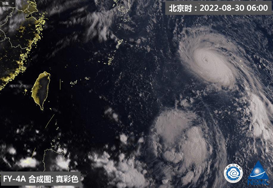
Xuanlannuo swallowed the tropical depression below @ Central Meteorological Observatory/Weibo.
It may just be the moment when the vast Yun Qi wind falls, and it goes north alone during the abrupt change of circulation in summer and autumn, carrying the endless long summer behind it, and creating a thousand autumn winds in front of it.
This paper will briefly explain the current and future influence of "Xuanlannuo".
Too long to read the version
"Xuanlannuo" belongs to the stronger level in the super typhoon level;
This year’s typhoon came not too late, but so far the number is small;
There is a high probability that Xuanlannuo will not land in China, but it will have an impact on coastal areas, especially in the eastern coastal areas of Zhejiang Province.
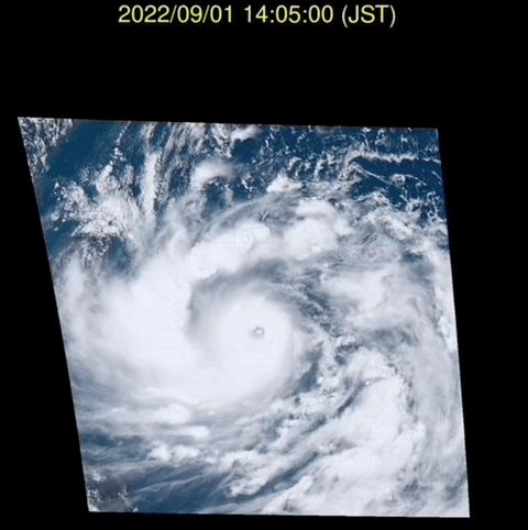
The surging "Xuanlannuo" instant webpage of Sunflower No.8
Super typhoon level, how strong is it?
"Xuanlannuo" was generated on the afternoon of August 28th, upgraded to super typhoon in the early morning of the 30th, and weakened from super typhoon level to strong typhoon level at 5 o’clock on the 2nd. According to the latest forecast, it moved into the East China Sea on the 3rd, and its intensity will be enhanced to super typhoon level again.
According to China’s typhoon classification method, the super typhoon level is the highest level. "Xuanlannuo" even belongs to the stronger level in the super typhoon level.
The classification of typhoon in China is based on the maximum wind speed near the typhoon center (specifically, the 2-minute average continuous maximum wind speed). When the maximum wind speed near the center exceeds 51m/s (equivalent to 16 or above), it is the highest level of super typhoon level.
At 14: 00 on September 1, the maximum wind speed near the center of Xuanlannuo reached 65 m/s, which exceeded the upper limit of the extended Beaufort scale of 17, which was a strong level in the super typhoon scale. As can be seen from the following figure, although there are about six typhoons reaching the super typhoon level every year in the northwest Pacific, there are only one or two typhoons reaching the current intensity of Xuanlannuo on average every year, which is also the strongest typhoon in the northwest Pacific so far this year.
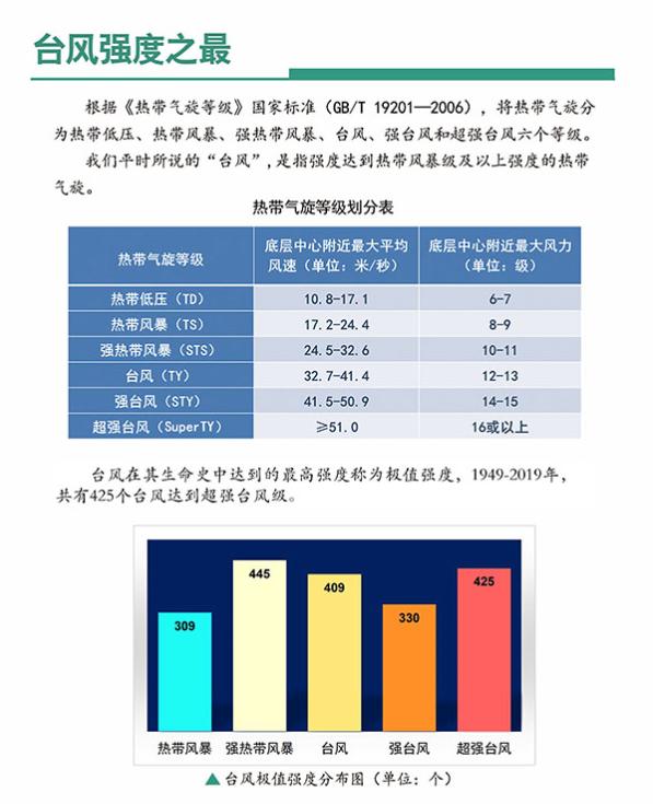
Typhoon intensity classification table in China and typhoon classification in 1949-2019, Central Meteorological Observatory
This year’s typhoon
Are you really late?
The first typhoon that landed in China this year was Typhoon Siam, which landed in Maoming on July 2, and it was not obviously late. However, the number of typhoons generated and landed in China this year is obviously less, and the landing sites are concentrated in the western part of Guangdong and Hainan, which has no obvious impact on the eastern and northern coasts of Guangdong, and further aggravates the impression that "typhoons come late".
So far this year, there have been 11 typhoons in the northwest Pacific, compared with an average of 14.1 from 1951 to 2010. There are three typhoons (tropical storms or stronger) landing in China, compared with about 4-5 in the same period from 1949 to 2019. It can be seen that the total number and level of typhoons are less.
The reason is the same as the biggest driver of the high temperature heat wave in the early summer in southern China, which is a significantly strong subtropical high.
As a system prevailing in a large area of downward flow, subtropical high not only caused a large range of blazing sunny and hot temperatures on land, but also shrouded the blue waves in the northwest Pacific Ocean. Under its control, it is difficult to have large-scale updraft and convective cloud activities in tropical waters, so it is difficult to have significant and sustained latent heat release of water vapor condensation and the development of near-surface low pressure, which seriously hinders the development mechanism of typhoons.
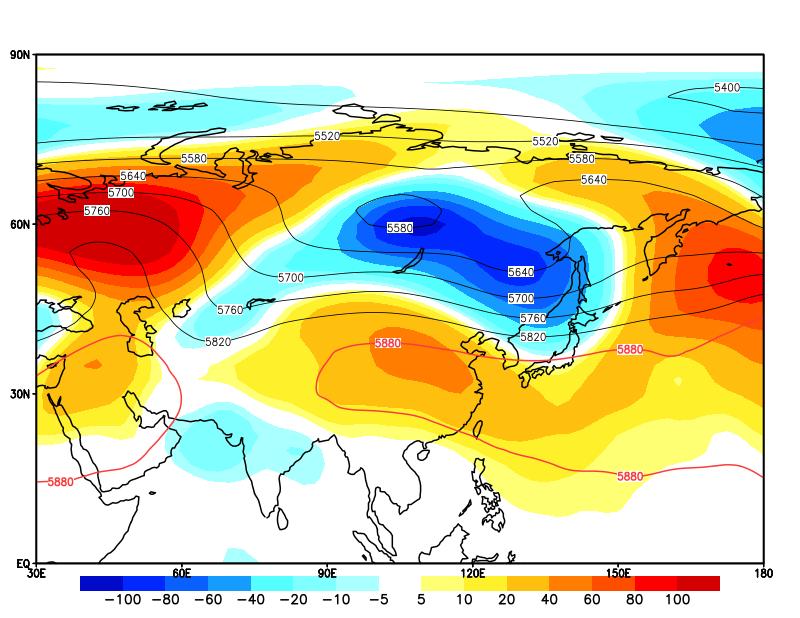
The geopotential height (isoline, unit gpm) in the middle troposphere (500hPa) and the anomaly value (color filling, unit gpm) from August 1 to 20. The red line 5880 surrounds the subtropical high range, and the accompanying positive anomaly represents the strong subtropical high.
Why is the subtropical high so strong this year? There are many specific reasons, but the most important one is related to the abnormal development of La Nina in spring and summer this year. Most La Nina events in history developed in the northern hemisphere in summer and autumn in the first year, peaked in winter, and then gradually declined in the spring of the second year. However, after the development of La Nina last autumn, it did not decay this spring, but further strengthened slightly, and reached its peak in May-June.
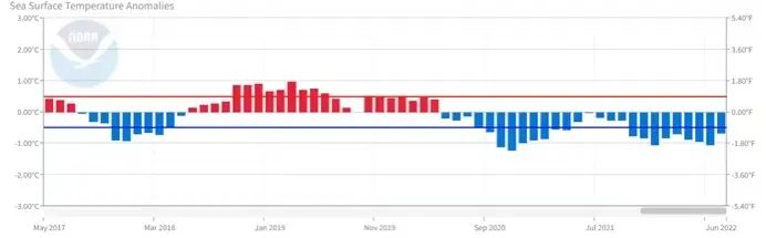
Monthly sea surface temperature anomalies in the monitoring area reflecting El Ni? o/La Ni? a events. It can be seen that the negative anomaly is still increasing this spring, which represents the abnormal development of La Nina event. What about the National Oceanic and Atmospheric Administration?
In general, the SST in the tropical Pacific is warm in the west and cold in the east. When La Ni? a event intensifies, the SST in the equatorial Middle East Pacific becomes lower, which causes the upper atmosphere to cool, contract and sink to form the ground high pressure. This enhanced pressure gradient in the east-west direction leads to the obvious enhancement of the trade winds crossing the tropical Pacific to the west. Strong trade winds induce an abnormal anticyclone to form on its north side, which is superimposed with the subtropical high, which is also an anticyclone in the middle and lower troposphere, so that the subtropical high is significantly enhanced.
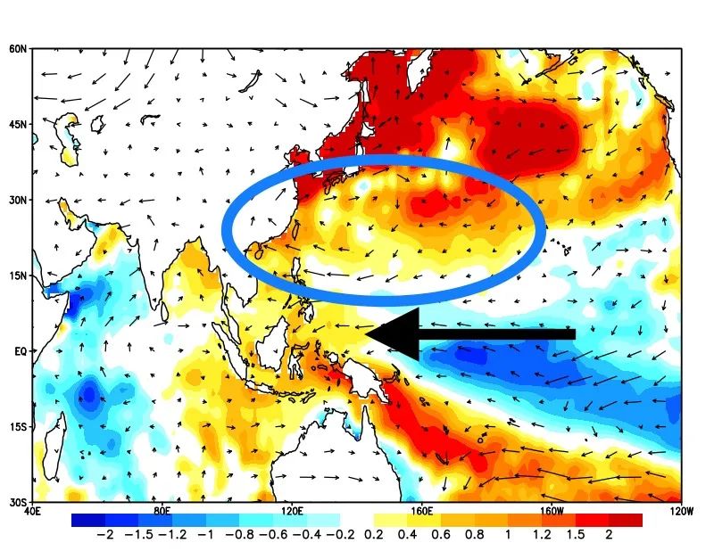
Same as above, but it is the anomaly of sea surface temperature (coloring) and wind field in the lower troposphere (850hPA). It can be seen that the equatorial Pacific trade wind is obviously stronger (along the black arrow) and the subtropical high is stronger (marked by the blue circle).
"Xuan Lan Nuo" wants great bend?
Where is the typhoon going?
Judging from the current forecast, "Xuanlannuo" presents a V-shaped position. The sharp change of typhoon track is related to the sharp change of subtropical high intensity and other tropical cyclones around it. To answer this question more specifically, we must first understand some basic attributes of typhoons.
Typhoon is essentially a deep cyclone that develops in tropical and subtropical sea areas. In the weather system, some weather systems wider than it will provide airflow to guide it to move, which is the main driving force of typhoon movement. The subtropical high, which has the largest overlap with the typhoon activity area, has become the most important system.
Year after year, the subtropical high moves obviously with the seasonal changes, following the sun to the north in spring and summer, and returning to the south in autumn and winter to avoid the cold wind. Therefore, typhoons generally follow this rule-the path is southward in winter and spring, which may affect the Philippines, Vietnam and other places; The north in summer and autumn affects China, Japan, South Korea and other places.
Because the position and intensity of subtropical high also change obviously in the short term, the specific typhoon path will be different. In addition, there are other factors that affect the typhoon path, one of which is the mutual rotation effect when two typhoons coexist and are close together. At this time, two typhoons will move around their center of mass, and the smaller typhoon will be more affected.
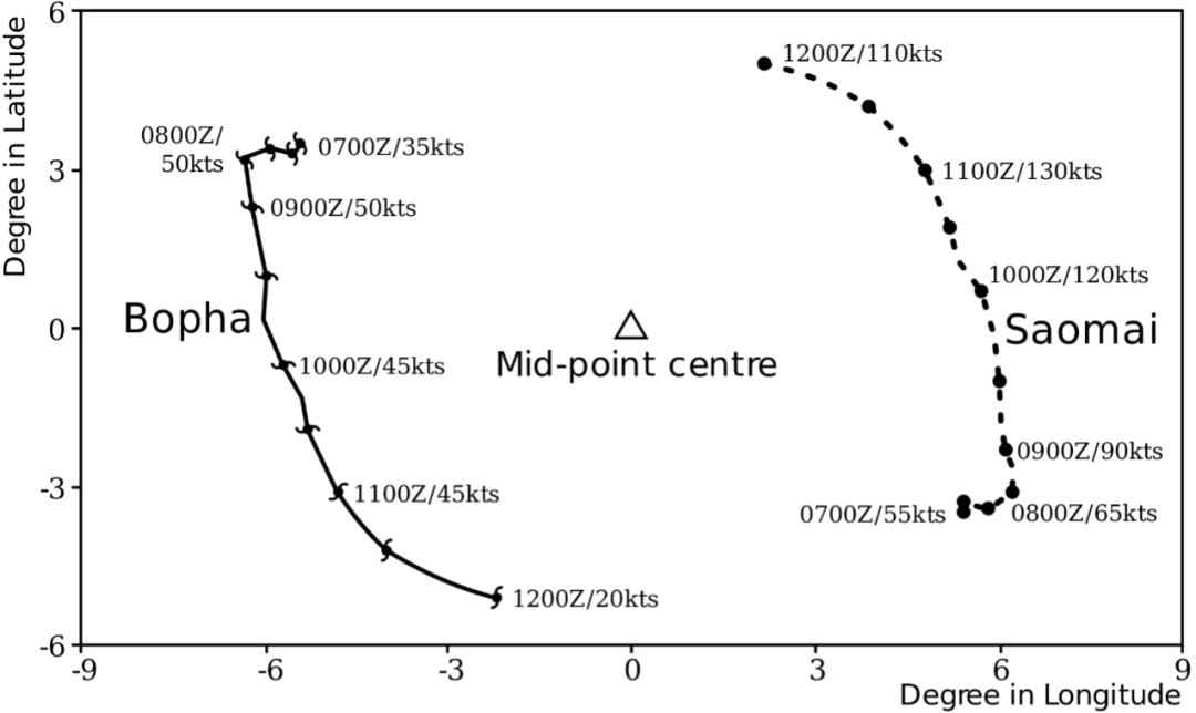
An example of mutual rotation effect between Typhoon Sang Mei and Typhoon Baoxia in 2000. What wikimommons
The sharp turn of the current "Xuanlannuo" path is the result of the rapid change of subtropical high intensity and the mutual rotation effect. Previously, the subtropical high was strong, just like a wall across the north side of Xuanlannuo, which also provided a strong steering flow to the west, allowing the typhoon to move rapidly to the southwest and west. At present, the subtropical high is significantly weakened by the influence of the westerly trough system on the north side, and just "disconnected" into two single systems on the north side of Xuanlannuo, in which the steering flow provided by the east unit is northward, while the west unit is southward. Two kinds of steering flow saws make the typhoon obviously slow down and stay, just like being stuck in a quagmire.
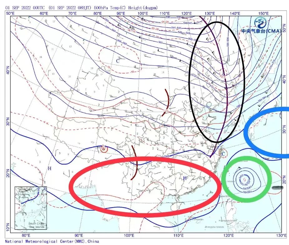
500hPa weather map at 8: 00 Beijing time on September 1st. It can be seen that with the influence of the westerly trough (black circle) on the north side, the subtropical high is about to break into the west side monomer (red circle) and the east side monomer (blue circle), which makes Xuanlannuo (green circle) suddenly confused.
While wandering, a new tropical depression formed beside the southeast side of Xuanlannuo. Due to the great strength gap between the two sides, this tropical depression has been swallowed up by Xuanlannuo, but its residual cloud system still has obvious mutual rotation effect with Xuanlannuo, which provides Xuanlannuo with a steering flow that goes east first and then north. With the further weakening of the west subtropical high monomer in the next day or two, "Xuanlannuo" will eventually move to the north under the joint action of the east subtropical high monomer and the mutual rotation effect, and enter the East China Sea. Because the specific intensity of subtropical high and the degree of mutual rotation effect caused by tropical low residual circulation still have variability, it is still possible to adjust the path of Xuanlannuo in the future.
How will the typhoon affect our country?
To sum up, although there are still a few variables, there is a high probability that "Xuanlannuo" will not land in China, but will go north in the eastern coastal areas of China and eventually tend to the southern coastal areas of South Korea. And in the process of going northward, China’s coastal area is located in the relative "safety semicircle" on its west side, and the wind and rain intensity will be relatively small, and the overall impact on land will not be serious.
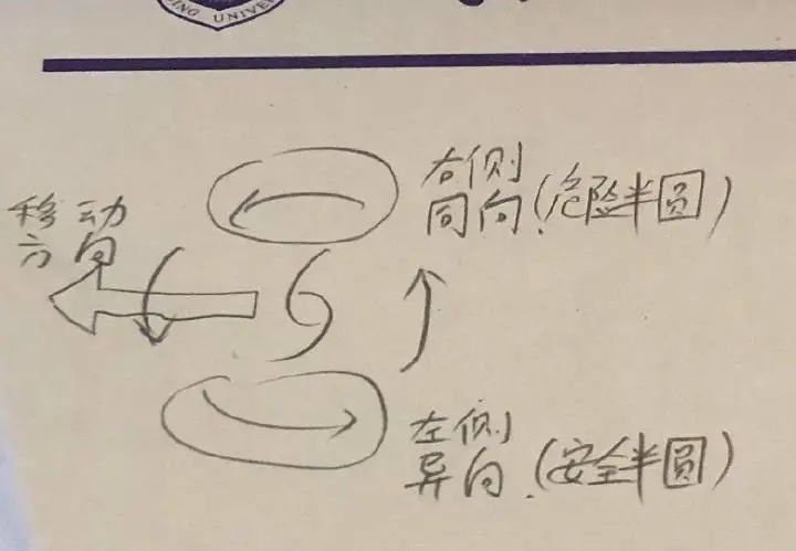
The superposition relationship between typhoon’s dangerous semicircle/safe semicircle and its own wind speed and moving speed. The author’s soul hand-painted
Even so, due to the significant expansion of the circulation scale of Xuanlannuo after the annexation of tropical depression, and the relatively slow weakening in the northward process, the strong typhoon will still be maintained to the super typhoon level, so the coastal areas such as eastern Taiwan Province, northeastern Fujian, Zhejiang coastal areas and Shanghai still need to pay attention to prevent the impact of wind and rain, among which Zhoushan Islands will be the most significantly affected; The offshore waters will be directly affected by typhoons and there will be violent storms. Offshore operators must return to Hong Kong to take shelter from the wind according to the early warning information.
I hope all the people affected by "Xuanlannuo" will be safe!
Author: Fengyun Mengyuan
Editor: Owl, Luna
Title source: Sunflower No.8 instant webpage

Read the original text